![[UK map]](/img/locationmap.png)
| OSGB36 trig archive spreadsheet - IW | |||||||||||||
|---|---|---|---|---|---|---|---|---|---|---|---|---|---|
| Trig Name | Original Name | New Name | EASTING | NORTHING | HEIGHT | ORDER | TYPE OF MARK | Computing Date | CLASS OF LEVELLING | Date of Levelling | LEVELLING DATUM | DESTROYED MARK INDICATOR | COMMENTS |
| Lift And Tank House | ST57/T252 | ST57T252 | 349748.28 | 178008.52 | 0.000 | 4 | RIVET | 01/06/1976 | 0 | 0 |
Nearby trigpoints, placenames
There are 4 photos for this trigpoint (view album).
This trigpoint:
Is ranked joint 19938th with 44 other trigs (more).
Has a mean score of 3.86/10 (from 7 logged visits)
Was First logged: 9th Mar 2011
Has never been found intact
Was Last logged: 17th Jan 2019
Of the 7 logged visits,
0 recorded a location
You are not logged in. You must login if you wish to log a visit.
![]() 17th Jan 2019 14:52 by Brisey
17th Jan 2019 14:52 by Brisey
FB Number: Not logged Condition: Inaccessible Score: 5/10
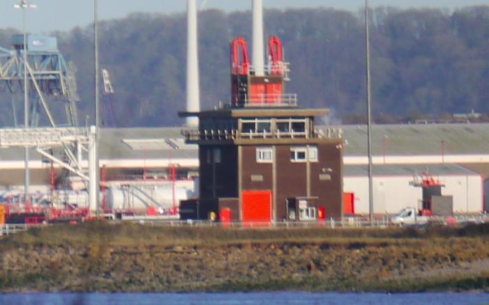
A view from Portishead encompasses much of the Royal Portbury Dock and Avonmouth Dock complex and this building can be seen. The satellite view on the Bing map link shows a building at the TP location with a shadow that matches the profile of the current building that can be seen.
![]() Docks view The building corresponding with the rivet location is on the right. At first I thought the large building in the background was the Spillers Silo TP10853 but it's a similar building out of shot.
Docks view The building corresponding with the rivet location is on the right. At first I thought the large building in the background was the Spillers Silo TP10853 but it's a similar building out of shot.![]() Zoom view
Zoom view
![]() 27th May 2016 15:09 by jonglew
27th May 2016 15:09 by jonglew
FB Number: Not logged Condition: Inaccessible Score: 4/10
From Sheepway walked along Wharf Lane, past the Portbury Wharf nature reserve area, turning E at end of the RoW, the path follows the top of the dyke to the boundary fencing for Bristol Port at ST 49040 77300, after which no further progress can be made. This is probably as close as is possible to get to the trig without a very dodgy trespass.
![]() 18th Aug 2015 18:00 by penfold1570
18th Aug 2015 18:00 by penfold1570
FB Number: Not logged Condition: Inaccessible Score: 5/10
![]() 1st Jun 2013 12:05 by bluebeard
1st Jun 2013 12:05 by bluebeard
FB Number: Not logged Condition: Inaccessible Score: 1/10
![]() 18th May 2013 08:45 by Trigger
18th May 2013 08:45 by Trigger
FB Number: Not logged Condition: Couldn't find it Score: 5/10
![]() 31st Mar 2013 09:54 by CJO
31st Mar 2013 09:54 by CJO
FB Number: Not logged Condition: Inaccessible Score: 5/10
ST57 T252 RIVET. located within the port complex access is restricted. From the hills to the SW (TP11487) it is possible to see a small tower behind the large warehouses structures. This is in the correct location for the Lift and Tank House, it is impossible to be 100% certain this is the correct building at this range, although it does match the photo on http://www.geograph.org.uk/photo/1142688. Even more difficult to confirm if rivet still exists.
![]() Lift and Tank House can you get any closer?
Lift and Tank House can you get any closer?
![]() 9th Mar 2011 13:21 by Dusty
9th Mar 2011 13:21 by Dusty
FB Number: Not logged Condition: Inaccessible Score: 2/10
Walked from Atherton House past Portbury Wharf. Wildlife area created with bird hides. Past Sewage Works and reached a point about 750m from trigpoint location.
![[map]](/img/trig-map.png.php?t=11492&b=2&l=0&)