![[UK map]](/img/locationmap.png)
| OSGB36 trig archive spreadsheet - IW | |||||||||||||
|---|---|---|---|---|---|---|---|---|---|---|---|---|---|
| Trig Name | Original Name | New Name | EASTING | NORTHING | HEIGHT | ORDER | TYPE OF MARK | Computing Date | CLASS OF LEVELLING | Date of Levelling | LEVELLING DATUM | DESTROYED MARK INDICATOR | COMMENTS |
| Brayton Barff West | SE44/24 | SE44S024 | 458203.07 | 430145.58 | 29.739 | 3 | PILLAR | 01/06/1948 | 1 | 01/06/1966 | N | 1 | Dest 08/86 |
Nearby trigpoints, placenames
There are 12 photos for this trigpoint (view album).
This trigpoint:
Is ranked joint 23280th with 13 other trigs (more).
Has a mean score of 2.85/10 (from 26 logged visits)
Was First logged: 13th May 2001
Has never been found intact
Was Last logged: 12th Apr 2024
Of the 26 logged visits,
3 recorded a location and of these....
All were within 532m
The average error was 195m
1 was exact
You are not logged in. You must login if you wish to log a visit.
Selection of photos for this Pillar. ©painterman61  By BasilDowl 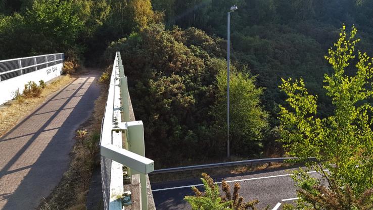 ©eon  By Dojmum  By John Riley  By John Riley See 6 more in the album. |
![]() 12th Apr 2024 00:00 by Ronaldo333
12th Apr 2024 00:00 by Ronaldo333
FB Number: Not logged Condition: Not Logged Score: 5/10
Brayton Barff West S1918 Dest. Roadside.
![]() 18th Mar 2023 09:40 by painterman61
18th Mar 2023 09:40 by painterman61
FB Number: Not logged Condition: Destroyed Score: 5/10
Nearby its gone
![]() It's outhere somewhere ©painterman61
It's outhere somewhere ©painterman61
![]() 6th Nov 2022 10:15 by A1Mushroom
6th Nov 2022 10:15 by A1Mushroom
FB Number: Not logged Condition: Destroyed Score: 5/10
Parked at the parking area for a quick pick, not playing with the traffic to cross the road to go on the hunt for something which isn't there.
![]() 22nd Aug 2022 12:40 by jonglew
22nd Aug 2022 12:40 by jonglew
FB Number: Not logged Condition: Destroyed Score: 5/10
Quick mooch around after the hill summit.
![]() 5th Jul 2021 14:20 by BasilDowl
5th Jul 2021 14:20 by BasilDowl
FB Number: Not logged Condition: Destroyed Score: 2/10
As others have noted, this one is long gone. According to the GPS, this would have been on what is now the bracken and gorse-covered northern embankment of the A63, just near where the bridge crosses the carriageway. There is a very handy parking pull just by the bridge; the lamp post featured in earlier photos has now gone.
![]() Somewhere to the right of the bridge
Somewhere to the right of the bridge
![]() 13th Oct 2018 11:00 by rupertal
13th Oct 2018 11:00 by rupertal
FB Number: Not logged Condition: Destroyed Score: 2/10
![]() 15th Jul 2018 08:06 by eon
15th Jul 2018 08:06 by eon
FB Number: Not logged Condition: Destroyed Score: 2/10
(865) Area viewed from the other side of the foot bridge over the A63. Pillar history: Built on the 30th of November 1937, cost and last maintained date by the OS not listed in the records. Marked as destroyed in August of 1986. FB was S1918.
![]() Brayton Barff West. ©eon
Brayton Barff West. ©eon
![]() 29th Oct 2017 13:19 by Dojmum
29th Oct 2017 13:19 by Dojmum
Gridref: SE 58576 30526 FB Number: Not logged Condition: Damaged Score: 8/10
it's here, but not your usual trig point. once had a Psalm on but was vandalised.
![]() slightly to the left on tap hill (the straight clearing)
slightly to the left on tap hill (the straight clearing)
![]() 8th Aug 2017 01:41 by Ant1974
8th Aug 2017 01:41 by Ant1974
FB Number: Not logged Condition: Destroyed Score: 5/10
![]() 23rd Jul 2017 00:00 by dogwalking
23rd Jul 2017 00:00 by dogwalking
Gridref: SE 58255 30155 FB Number: Not logged Condition: Destroyed Score: 0/10
gone
![]() 14th Apr 2017 09:55 by dugswell2
14th Apr 2017 09:55 by dugswell2
FB Number: GONE Condition: Destroyed Score: 3/10
Long gone, visited after Brayton Barff a new Tump discovered by CJO.
![]() 4th Apr 2014 14:14 by vegibagger
4th Apr 2014 14:14 by vegibagger
FB Number: Not logged Condition: Destroyed Score: 5/10
guesswork date as didn't note it when I wandered round reservoir of Brayton Barf
![]() 18th Mar 2013 17:46 by The RockKnocker
18th Mar 2013 17:46 by The RockKnocker
FB Number: Not logged Condition: Destroyed Score: 0/10
Must have been dug up and removed when the Selby bypass was built.
![]() 22nd Sep 2012 11:05 by CJO
22nd Sep 2012 11:05 by CJO
FB Number: Not logged Condition: Destroyed Score: 3/10
Climbed upto the footbridge from roadlevel. As previously reported location is in the middle of some gorse bushes
![]() 20th Apr 2012 19:39 by peregrinus
20th Apr 2012 19:39 by peregrinus
FB Number: Not logged Condition: Destroyed Score: 3/10
As per ted's log and OS trig archive, Dest 08/86, long before the A63 bypass came this way. My GPSr placed it N side of cutting, a few metres E of footpath, in broom scrub. It appears the ground may have been lowered at some stage. Parking in the A63 layby I had an interesting little scramble to reach footpath level!
![]() ex trig site is on opposite bank, L of lighting column
ex trig site is on opposite bank, L of lighting column ![]() ex trig site (or maybe a few m above)
ex trig site (or maybe a few m above)
![]() 12th Mar 2012 18:42 by PeteBoggs
12th Mar 2012 18:42 by PeteBoggs
FB Number: Not logged Condition: Destroyed Score: 2/10
Another trig lost to a road.Parked in lay-by and had a look around but nothing to see
![]() 10th Oct 2011 17:18 by Border Peat
10th Oct 2011 17:18 by Border Peat
Gridref: SE 58203 30146 FB Number: S1918 Condition: Destroyed Score: 3/10
Another missing trig due to a new road.
![]() 8th Sep 2011 14:10 by Particle
8th Sep 2011 14:10 by Particle
FB Number: Not logged Condition: Destroyed Score: 4/10
Stopped in layby and walked up not expecting to find anything. Gave directions to a couple following an old map that didn't have the new A63 road on it.
![]() 19th Jul 2011 18:21 by haighr01
19th Jul 2011 18:21 by haighr01
FB Number: Not logged Condition: Destroyed Score: 2/10
Spent the weekend prior at Scalm Park camping, so today visited Brayton Barff out of interest. Noted this is the first log for over two years. No sign of anything trig like - the young trees planted on the S side of the road in earlier photos have grown a bit. I guess S1918 went when the A63 was diverted around Selby. Shame, but this is not Yorkshire's greatest vista, although I don't mind Selby really. The Barff makes for a pleasant stroll, but this is not trigpoint country as such. So no trig, no golf balls but I did find a pack of polos. Did I eat any? No.
![]() 21st Apr 2009 16:00 by splash
21st Apr 2009 16:00 by splash
FB Number: Not logged Condition: Destroyed Score: 3/10
![]() 29th May 2007 16:23 by John Riley
29th May 2007 16:23 by John Riley
FB Number: Not logged Condition: Destroyed Score: 3/10
Today's visit was my first since 1984. I competed in orienteering events here on 10-07-83 and 08-01-84. The events were organised by the York based club Eborienteers. On both occasions the trig was a control point on the course I did. I have scanned part of the map showing the position of the trig at the time.
![]() Brayton Barff West View across the now missing site of the trig.
Brayton Barff West View across the now missing site of the trig.![]() Brayton Barff West Part of the old O-map of Brayton Barff showing the trigpoint at Control No 3 © G.Goodridge & S.Whitehead 1981.
Brayton Barff West Part of the old O-map of Brayton Barff showing the trigpoint at Control No 3 © G.Goodridge & S.Whitehead 1981.
![]() 10th Dec 2005 09:15 by ted
10th Dec 2005 09:15 by ted
FB Number: Not logged Condition: Destroyed Score: 0/10
Gone. If its reported date of demise (S1918, destroyed 1986 OS/Trigonomy) is correct then this predates the bypass construction; maybe the golfers got it. Found a bag of golf balls but no base. Best guess is that it was on the SW side of the road and a little SE from the bridge. Given the scarcity of higher ground, the hilltop would have been a better trig site for views over Selby but presumably the woodland prevented that option. Perhaps there was a non-pillar station Brayton Barff East?
![]() Brayton Barff no trig
Brayton Barff no trig
![]() 7th May 2005 11:15 by Kev W
7th May 2005 11:15 by Kev W
FB Number: Not logged Condition: Destroyed Score: 2/10
Nice road, no Trigpoint
![]() 28th May 2004 12:00 by iainmac
28th May 2004 12:00 by iainmac
FB Number: Not logged Condition: Destroyed Score: 0/10
My GPS indicated gone directly in cutting but will return to see if I can find base sometime. On my first visit I may have missed seeing this one by only a few weeks; the new road doesnt seem to carry much traffic either.
![]()
![]() 23rd May 2004 20:38 by stonestreaker
23rd May 2004 20:38 by stonestreaker
FB Number: Not logged Condition: Destroyed Score: 0/10
another new road splitting everything in half. looks like the trigg's been sacrificed to the petrol god too. Found the base, left a golf ball on top.
![]()
![]() 13th May 2001 12:30 by sleepwalker
13th May 2001 12:30 by sleepwalker
FB Number: Not logged Condition: Destroyed Score: 2/10
A full sweep of the area produced no trace of the column.
![[map]](/img/trig-map.png.php?t=1603&b=2&l=0&)