![[UK map]](/img/locationmap.png)
| OSGB36 trig archive spreadsheet - IW | |||||||||||||
|---|---|---|---|---|---|---|---|---|---|---|---|---|---|
| Trig Name | Original Name | New Name | EASTING | NORTHING | HEIGHT | ORDER | TYPE OF MARK | Computing Date | CLASS OF LEVELLING | Date of Levelling | LEVELLING DATUM | DESTROYED MARK INDICATOR | COMMENTS |
| Edenbrook | SU77/T239 | SU77T239 | 485757.49 | 158438.63 | 0.000 | 4 | BLOCK | 01/06/1955 | 0 | 1 | Dest 05/78 |
Nearby trigpoints, placenames
There are 8 photos for this trigpoint (view album).
This trigpoint:
Is ranked joint 12914th with 167 other trigs (more).
Has a mean score of 5.00/10 (from 5 logged visits)
Was First logged: 18th Jan 2018
Was Last logged: 20th Sep 2020
Of the 5 logged visits,
2 recorded a location and of these....
All were within 2m
The average error was 1m
The closest was 1m
You are not logged in. You must login if you wish to log a visit.
Selection of photos for this Block. ©jonglew  ©jonglew  ©jonglew 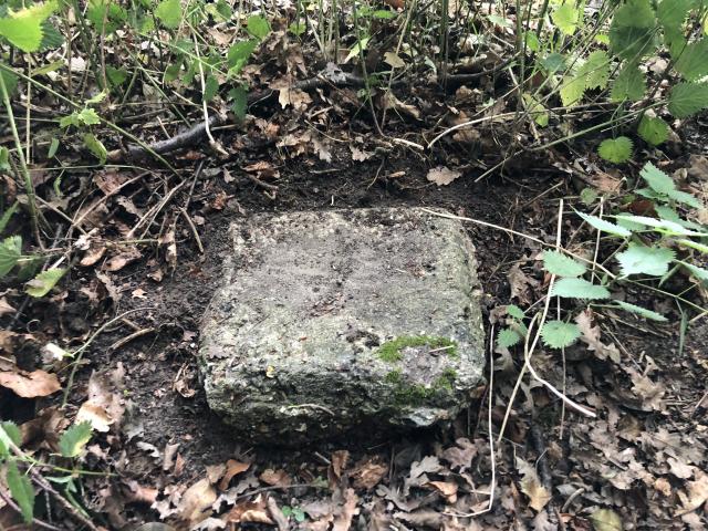 By TrigJS  By TrigJS  By Trigger See 2 more in the album. |
![]() 20th Sep 2020 16:32 by jonglew
20th Sep 2020 16:32 by jonglew
Gridref: SU 85759 58439 FB Number: Not logged Condition: Good Score: 5/10
Not possible to spot this from the lane, it's level with the ground, maybe 1-2" protruding. Looks like the site is being redeveloped, residential housing perhaps. There is heras fencing round it, but access still possible at present from SU 8592 5839, then on field boundaries skirting round outwith the fencing, lot of bramble to deal with though. Rod-style rivet protrudes sub-1cm from the block.
![]() Location TP21496©jonglew
Location TP21496©jonglew![]() The Block TP21496©jonglew
The Block TP21496©jonglew![]() The reference point TP21496©jonglew
The reference point TP21496©jonglew
![]() 19th Feb 2020 13:05 by mattandsophie
19th Feb 2020 13:05 by mattandsophie
FB Number: Not logged Condition: Inaccessible Score: 5/10
Inaccessible. Viewed from nearby lane
![]() 16th Jun 2019 23:08 by Ant1974
16th Jun 2019 23:08 by Ant1974
FB Number: Not logged Condition: Destroyed Score: 5/10
![]() 8th Jun 2018 11:24 by TrigJS
8th Jun 2018 11:24 by TrigJS
Gridref: SU 85758 58438 FB Number: Not logged Condition: Good Score: 5/10
OS has this trig point logged as destroyed. This doesnt appear to be the case though as the block was found in the expected location. Block in good condition at the surface and doesnt appear to have been disturbed. There is a gate to access the field at the intersection of Fernhill Lane and Hawley Road.
![]() TP21496 The block.
TP21496 The block.![]() TP21496 Close up of the survey marker.
TP21496 Close up of the survey marker.![]() TP21496 Location of the block near to the fence.
TP21496 Location of the block near to the fence.![]() TP21496 Entrance to the field.
TP21496 Entrance to the field.
![]() 18th Jan 2018 14:31 by Trigger
18th Jan 2018 14:31 by Trigger
FB Number: Not logged Condition: Couldn't find it Score: 5/10
![[map]](/img/trig-map.png.php?t=21496&b=2&l=0&)