![[UK map]](/img/locationmap.png)
| OSGB36 trig archive spreadsheet - IW | |||||||||||||
|---|---|---|---|---|---|---|---|---|---|---|---|---|---|
| Trig Name | Original Name | New Name | EASTING | NORTHING | HEIGHT | ORDER | TYPE OF MARK | Computing Date | CLASS OF LEVELLING | Date of Levelling | LEVELLING DATUM | DESTROYED MARK INDICATOR | COMMENTS |
| Doeshill | TQ87/T157 | TQ87T157 | 572879.50 | 192673.18 | 0.000 | 3 | PILLAR | 01/06/1984 | 0 | 0 | 4/94 TO BE DEMOLISHED | ||
| Doeshill | TQ87/T157 | TQ87T157 | 572879.43 | 192673.13 | 38.508 | 3 | PILLAR | 01/06/1946 | 1 | 01/10/1961 | N | 1 | Refixed 1984 |
Nearby trigpoints, placenames
There are 3 photos for this trigpoint (view album).
This trigpoint:
Is ranked joint 20187th with 50 other trigs (more).
Has a mean score of 3.67/10 (from 6 logged visits)
Was First logged: 31st Aug 2003
Has never been found intact
Was Last logged: 25th Oct 2021
Of the 6 logged visits,
0 recorded a location
You are not logged in. You must login if you wish to log a visit.
Selection of photos for this Pillar. By CJO 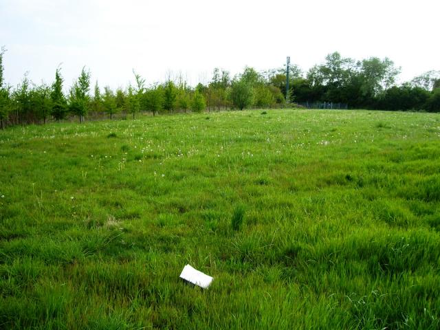 By peregrinus 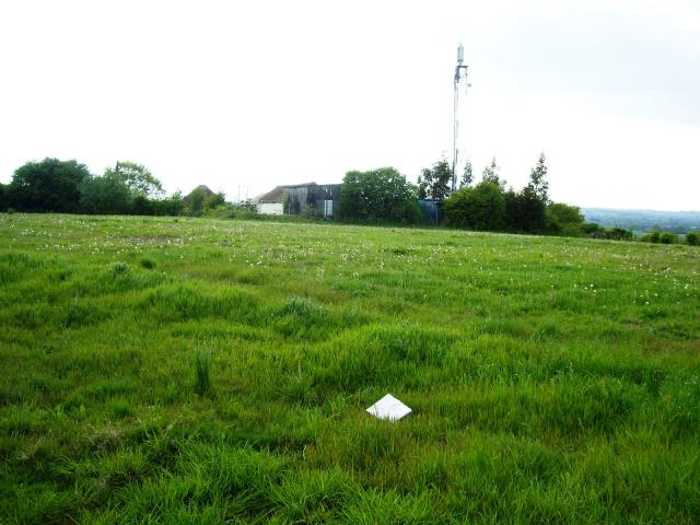 By peregrinus |
![]() 25th Oct 2021 15:20 by A1Mushroom
25th Oct 2021 15:20 by A1Mushroom
FB Number: Not logged Condition: Destroyed Score: 5/10
Drove up the residential road to near the masts where there is a small parking area and a path through the wood / hedge to the field where the trig used to be.
![]() 6th Apr 2018 09:25 by CJO
6th Apr 2018 09:25 by CJO
FB Number: Not logged Condition: Destroyed Score: 5/10
Drove to end of residential track. Nothing obvious - field still empty.
![]() 19th Oct 2016 12:19 by Ant1974
19th Oct 2016 12:19 by Ant1974
FB Number: Not logged Condition: Destroyed Score: 5/10
![]() 6th May 2010 18:00 by peregrinus
6th May 2010 18:00 by peregrinus
FB Number: Not logged Condition: Destroyed Score: 2/10
Still missing, still setaside, GPS indicated 50ish m SE from transmitter buildings. I asked at Doeshill Farm but an old farmhand there knew nothing of a trig and they dont farm that land anyway. He referred me to Barleylands (a big setup further west). I called into the office there and the Commercial manager checked on Google Maps, confirmed the location was theirs, and in setaside. He subsequently advised: <I have spoken to the foreman and Director who farms that section of land and they cannot ever remember seeing it. I have had a look around our storage sheds here and found nothing.> I couldnt relocate the local resident from before for any more clues.
![]() ex trig location, looking NW to mast
ex trig location, looking NW to mast ![]() ex trig location, looking SW to other mast
ex trig location, looking SW to other mast
![]() 28th Mar 2004 15:40 by NeverLost
28th Mar 2004 15:40 by NeverLost
FB Number: Not logged Condition: Destroyed Score: 0/10
After scratching around in the bush for a while a local chap, curious as to my activities, explained in some detail that the local farmer had pulled the trig out using his tractor and it had laid in his farmyard for some years but was unsure whether it was still there. It definately wasn't where it should be!
![]() 31st Aug 2003 12:00 by peregrinus
31st Aug 2003 12:00 by peregrinus
FB Number: Not logged Condition: Destroyed Score: 5/10
gone - setaside, farmer removed it c.2001 & put it in his yard according to resident of adjacent house. So who will refind it .. Doeshill Fm to SSE? OS trig archive says: 4/94 TO BE DEMOLISHED but no record of the deed being done. Also says Refixed 1984 (within a few cm of original location) FB was S3447. Jim Cain bagged it 21/08/1990.
![[map]](/img/trig-map.png.php?t=2801&b=2&l=0&)