![[UK map]](/img/locationmap.png)
| OSGB36 trig archive spreadsheet - IW | |||||||||||||
|---|---|---|---|---|---|---|---|---|---|---|---|---|---|
| Trig Name | Original Name | New Name | EASTING | NORTHING | HEIGHT | ORDER | TYPE OF MARK | Computing Date | CLASS OF LEVELLING | Date of Levelling | LEVELLING DATUM | DESTROYED MARK INDICATOR | COMMENTS |
| Kedington | TL74/T35 | TL74T035 | 568945.25 | 246325.09 | 96.566 | 3 | PILLAR | 01/11/1986 | 1 | 01/06/1956 | N | 0 | |
| Kedington | TL74/T35 | TL74T035 | 568945.48 | 246325.20 | 96.572 | 3 | PILLAR | 01/06/1948 | 1 | 01/05/1950 | N | 1 | Recomputed 11/86 |
Nearby trigpoints, placenames
There are 15 photos for this trigpoint (view album).
This trigpoint:
Is ranked joint 15188th with 81 other trigs (more).
Has a mean score of 4.78/10 (from 18 logged visits)
Was First logged: 1st Jun 2003
Was Last found intact: 30th Apr 2022
Was Last logged: 14th Jan 2024
Of the 18 logged visits,
8 recorded a location and of these....
All were within 128m
The average error was 39m
2 were exact
You are not logged in. You must login if you wish to log a visit.
Selection of photos for this Pillar. By wrose  By wrose 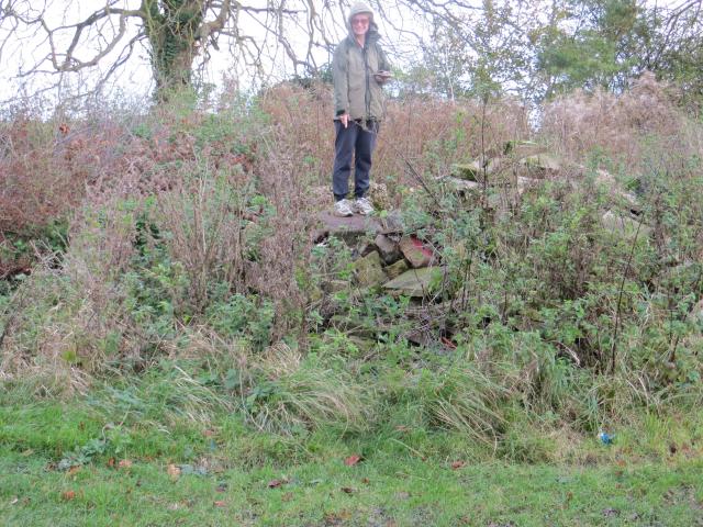 By wrose  By wrose  By mitsiman 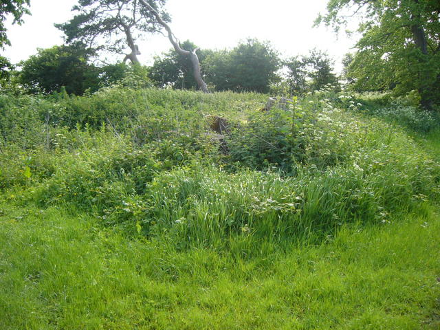 By iainmac 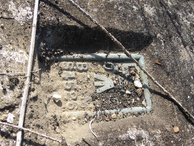 By iainmac 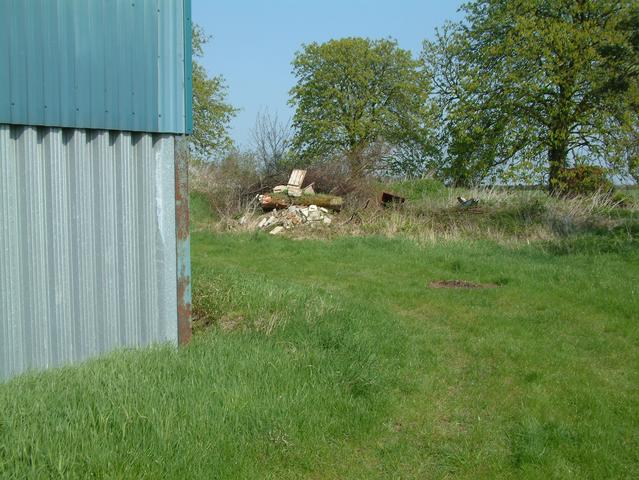 ©rad See 7 more in the album. |
![]() 14th Jan 2024 13:24 by RGChandler
14th Jan 2024 13:24 by RGChandler
FB Number: S4526 Condition: Moved Score: 5/10
Still languishing on a pile of rubble behind the blue barn. In quite good condition, all things considered.
![]() 30th Apr 2022 15:39 by DaveD
30th Apr 2022 15:39 by DaveD
FB Number: Not logged Condition: Slightly damaged Score: 5/10
7/7 with Debi. Such a shame it's dumped like that - still in not bad condition with all metal work. What harm was it doing sat round the corner next to the path where it should be!?
![]() 27th Mar 2022 21:49 by WanderingSal
27th Mar 2022 21:49 by WanderingSal
FB Number: Not logged Condition: Moved Score: 5/10
![]() 30th Jul 2020 16:50 by Mickandkim
30th Jul 2020 16:50 by Mickandkim
Gridref: TL 68897 46343 FB Number: S4526 Condition: Moved Score: 3/10
Drove to it and found it in nettles
![]() 24th Jan 2020 16:09 by HH
24th Jan 2020 16:09 by HH
Gridref: TL 69025 46337 FB Number: Not logged Condition: Not Logged Score: 5/10
![]() 24th Jan 2020 16:06 by HH
24th Jan 2020 16:06 by HH
Gridref: TL 68913 46324 FB Number: Not logged Condition: Not Logged Score: 5/10
![]() 2nd Mar 2018 10:46 by slateloose
2nd Mar 2018 10:46 by slateloose
Gridref: TL 68800 46300 FB Number: S4526 Condition: Moved Score: 5/10
The trig point is still at the back of the farm build in a pile of rubble 13 years after it was moved. A little harder to find today with a covering of snow. It would take no time at all with a tractor and sling to pick it up and place it back near the footpath. Someday maybe.
![]() 30th Aug 2016 19:58 by THE CYCLIST
30th Aug 2016 19:58 by THE CYCLIST
FB Number: S4526 Condition: Moved Score: 5/10
No problem in locating on pile of broken concrete at back of barn
![]() 14th Feb 2015 14:10 by Tomaszewski
14th Feb 2015 14:10 by Tomaszewski
FB Number: S4526 Condition: Moved Score: 5/10
Interesting taking a photo of a fb whilst standing on the side of it . Still in a pile of building rubbish although not overgrown at this time of year . Bagged the original spot as gps guide me to it on the way to trig .
![]() 12th Nov 2014 11:19 by wrose
12th Nov 2014 11:19 by wrose
Gridref: TL 68897 46343 FB Number: S4526 Condition: Moved Score: 6/10
Took some digging out but it is still in the pile of rubbish. Fortunately the Flush Bracket faces upward. Correct condition is Toppled AND Moved!
![]() S4526 Kedington Found it!
S4526 Kedington Found it!![]() S4526 Kedington Pillar.
S4526 Kedington Pillar.![]() S4526 Kedington Flush Bracket.
S4526 Kedington Flush Bracket.![]() S4526 Kedington Plug.
S4526 Kedington Plug.
![]() 12th Nov 2014 00:00 by caroleengel
12th Nov 2014 00:00 by caroleengel
Gridref: TL 68893 46343 FB Number: Not logged Condition: Moved Score: 5/10
Still in pile of rubble opposite support strut of most north easterly building in yard - not an easy find. Uncovered it as best possible
![]() 6th Jul 2010 18:30 by mitsiman
6th Jul 2010 18:30 by mitsiman
FB Number: Not logged Condition: Toppled Score: 5/10
A very sad end...
![]()
![]() 25th Aug 2009 20:08 by Griefmiester
25th Aug 2009 20:08 by Griefmiester
FB Number: S4526 Condition: Toppled Score: 5/10
Located in a pile of rubbish/hardcore in a farm yard, very sad looking position, brass work still in tact.
![]()
![]() 19th May 2007 12:00 by iainmac
19th May 2007 12:00 by iainmac
Gridref: TL 68900 46340 FB Number: S4526 Condition: Toppled Score: 1/10
![]() 17th Apr 2005 11:00 by rad
17th Apr 2005 11:00 by rad
FB Number: S4526 Condition: Toppled Score: 5/10
Definitely removed to behind nearby farm buildings. Now located on back of rubble pile at TL 68870 46320.
![]() View of rubble pile from path.©rad
View of rubble pile from path.©rad![]() ©rad
©rad![]() ©rad
©rad
![]() 26th May 2004 15:22 by donohoep
26th May 2004 15:22 by donohoep
FB Number: S4526 Condition: Toppled Score: 5/10
Sorry to say that this TP has had its day. It has been dug up and is now situated atop a pile of rubble behind the barn's at Great Wilsey Farm.
![]() 30th Aug 2003 12:00 by peregrinus
30th Aug 2003 12:00 by peregrinus
FB Number: S4526 Condition: Good Score: 5/10
vgc? hiding in blackthorn N edge of FP not easy to examine
![]() 1st Jun 2003 16:51 by Pharisee
1st Jun 2003 16:51 by Pharisee
Gridref: TL 68946 46328 FB Number: S4526 Condition: Good Score: 6/10
Located just off a public footpath very close to Great Wilsey Farm, a kilometre or so to the north east of Haverhill. It is complete and in good condition but almost totally obscured by a large bush that has grown up around it. It is aligned on the cardinal compass points with the flush plate on the south face. Access is easy as this appears to be a well used footpath but I suspect that very few of the users are aware of the T/Ps presence. Certainly the couple that stopped for a chat while I was photographing it had no idea that it was there or indeed what it was. I parked in a side street just off the B1061 at the eastern end of the footpath in the village of Kedington. The footpath is easy to find and well signposted. Whilst not being particularly high the views in most directions are fairly good, mostly over rolling farmland with Haverhill tucked away in a valley to the south west.
![]() The Trig Point and its surrounding bush.
The Trig Point and its surrounding bush.![]() The Flush Bracket
The Flush Bracket ![]() The view south towards Haverhill
The view south towards Haverhill
![[map]](/img/trig-map.png.php?t=4143&b=2&l=0&)