![[UK map]](/img/locationmap.png)
| OSGB36 trig archive spreadsheet - IW | |||||||||||||
|---|---|---|---|---|---|---|---|---|---|---|---|---|---|
| Trig Name | Original Name | New Name | EASTING | NORTHING | HEIGHT | ORDER | TYPE OF MARK | Computing Date | CLASS OF LEVELLING | Date of Levelling | LEVELLING DATUM | DESTROYED MARK INDICATOR | COMMENTS |
| Figsbury Ring | SU31/T338 | SU31T338 | 418702.13 | 133883.15 | 0.000 | 4 | BLOCK | 01/06/1950 | 0 | 0 |
Nearby trigpoints, placenames
There are 10 photos for this trigpoint (view album).
This trigpoint:
Is ranked joint 3404th with 37 other trigs (more).
Has a mean score of 6.07/10 (from 15 logged visits)
Was First logged: 15th Jan 2012
Was Last logged: 27th May 2023
Of the 15 logged visits,
3 recorded a location and of these....
All were within 131m
The average error was 46m
The closest was 1m
You are not logged in. You must login if you wish to log a visit.
Selection of photos for this Surface Block. By Andy West  ©natmil  ©COVID Trig Point Challenge 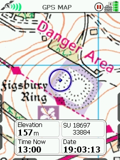 By Griefmiester 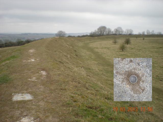 By Griefmiester  By Trigger See 4 more in the album. |
![]() 27th May 2023 10:38 by Andy West
27th May 2023 10:38 by Andy West
FB Number: Not logged Condition: Good Score: 7/10
![]()
![]() 15th May 2022 13:18 by natmil
15th May 2022 13:18 by natmil
FB Number: Not logged Condition: Slightly damaged Score: 7/10
Stunning views
![]() ©natmil
©natmil
![]() 23rd Apr 2021 00:00 by Woodleywalker
23rd Apr 2021 00:00 by Woodleywalker
FB Number: Not logged Condition: Good Score: 7/10
Good St George's day visit, easy to find with it's concrete surround, start of a five mile section of the Monarchs Way and back.
![]() 25th May 2020 06:59 by COVID Trig Point Challenge
25th May 2020 06:59 by COVID Trig Point Challenge
FB Number: Not logged Condition: Good Score: 10/10
![]() ©COVID Trig Point Challenge
©COVID Trig Point Challenge
![]() 12th Aug 2019 20:39 by Ant1974
12th Aug 2019 20:39 by Ant1974
FB Number: Not logged Condition: Good Score: 5/10
![]() 7th Sep 2018 13:30 by Wubbleyew
7th Sep 2018 13:30 by Wubbleyew
FB Number: Not logged Condition: Good Score: 7/10
Wonderful Iron Age fort enclosing 16 acres with entrances to the east and west. Unusually, it has a concentric ditch within. Walked the full encirclement, claiming the surface block as we did so. Good views over the Avon Valley with Salisbury Cathedral prominent.
![]() 25th Feb 2018 12:47 by Roger Peaple
25th Feb 2018 12:47 by Roger Peaple
Gridref: SU 18600 33800 FB Number: Not logged Condition: Slightly damaged Score: 9/10
Stumbled across on an impromptu ramlble! Wonderful views :-)
![]() 23rd Nov 2016 09:30 by dbattyman
23rd Nov 2016 09:30 by dbattyman
FB Number: Not logged Condition: Not Logged Score: 5/10
![]() 31st Aug 2015 06:45 by peregrinus
31st Aug 2015 06:45 by peregrinus
FB Number: Not logged Condition: Slightly damaged Score: 5/10
2.5" bolt in block, slightly tatty from trampling, obvious on path along top of earth rampant. Impressive place
![]() 20th Nov 2014 15:00 by bluebeard
20th Nov 2014 15:00 by bluebeard
FB Number: Not logged Condition: Good Score: 1/10
![]() 2nd Aug 2014 15:15 by dal
2nd Aug 2014 15:15 by dal
FB Number: Not logged Condition: Good Score: 7/10
Straightforward. Delightful spot.
![]() 19th Mar 2013 13:00 by Griefmiester
19th Mar 2013 13:00 by Griefmiester
Gridref: SU 18697 33884 FB Number: Not logged Condition: Good Score: 5/10
Easily located Surface Block on North West side of large hill fort - interesting location - views all around - all appears to be in good condition.
![]() 5th Mar 2013 09:23 by jonglew
5th Mar 2013 09:23 by jonglew
Gridref: SU 18703 33884 FB Number: Not logged Condition: Good Score: 6/10
Located on the western side of the hillfort ramparts with very good views to the North, and West across the Avon valley. The surface block is a rough cast of concrete with its bolt in the centre, very easy to spot. The hillfort is unusual in that it has an inner ditch cut at a regular distance from the main ramparts. NT car park to the east or alternatively there is parking to the NW in Winterbourne Dauntsey near the railway line, with a walk along the Monarch way to the trig.
![]() Montage TP7907©jonglew
Montage TP7907©jonglew
![]() 23rd Jan 2012 07:31 by Trigger
23rd Jan 2012 07:31 by Trigger
FB Number: Not logged Condition: Good Score: 5/10
![]() 15th Jan 2012 14:20 by tom
15th Jan 2012 14:20 by tom
FB Number: Not logged Condition: Good Score: 5/10
The non pillar trig, SU31 T338, is situated on the north western rampart of an ancient earthwork on the edge of the downs to the north east of Salisbury. The trig consists of a two inch diameter bolt set into a rough two foot square surface block. The scheduled ancient monument is owned by the National Trust and there is a car park at the end of a bumpy lane to the east. A circuit of the outer embankment is rewarded with extensive views of the surrounding downs. From the trig the spire of Salisbury Cathedral could be seen emerging from the valley to the south west with the West Wiltshire Downs in the distance. Gently rolling downland stretches into the distance towards the interior of Salisbury Plain to the north west and Beacon Hill is to the north. Porton Down could be seen to the north east. The site has been designated a SSSI.
![]()
![]()
![[map]](/img/trig-map.png.php?t=7907&b=2&l=0&)