![[UK map]](/img/locationmap.png)
| OSGB36 trig archive spreadsheet - IW | |||||||||||||
|---|---|---|---|---|---|---|---|---|---|---|---|---|---|
| Trig Name | Original Name | New Name | EASTING | NORTHING | HEIGHT | ORDER | TYPE OF MARK | Computing Date | CLASS OF LEVELLING | Date of Levelling | LEVELLING DATUM | DESTROYED MARK INDICATOR | COMMENTS |
| Boys Rock (St Agnes) | SV91/15 | SV91S015 | 88254.90 | 7699.59 | 0.000 | 2 | BOLT | 01/06/1947 | 0 | 1 | Bolt in rock. Dest 07/60 |
Nearby trigpoints, placenames
There are 4 photos for this trigpoint (view album).
This trigpoint:
Is ranked joint 4888th with 85 other trigs (more).
Has a mean score of 5.71/10 (from 7 logged visits)
Was First logged: 1st Sep 2008
Has never been found intact
Was Last logged: 6th Jul 2022
Of the 7 logged visits,
0 recorded a location
You are not logged in. You must login if you wish to log a visit.
![]() 6th Jul 2022 13:39 by CJO
6th Jul 2022 13:39 by CJO
FB Number: Not logged Condition: Destroyed Score: 5/10
Paths network through short grass between gorse. Large boulders to west. Suspect this is on a grassed over slab. No sign of witness rivets either.
![]() One of these flat slabs if it is still there and OS simply couldnt find it in a re-visit
One of these flat slabs if it is still there and OS simply couldnt find it in a re-visit
![]() 6th Jul 2016 12:22 by peregrinus
6th Jul 2016 12:22 by peregrinus
FB Number: Not logged Condition: Destroyed Score: 5/10
Gps points to obvious small rock slab just E of the southernmost outcrop. No trace of bolt or remains or scar.p
![]() 6th Jul 2016 11:40 by dugswell2
6th Jul 2016 11:40 by dugswell2
FB Number: Not logged Condition: Destroyed Score: 7/10
A lovely spot none the less.
![]() 17th May 2016 13:50 by JonT
17th May 2016 13:50 by JonT
FB Number: Not logged Condition: Destroyed Score: 8/10
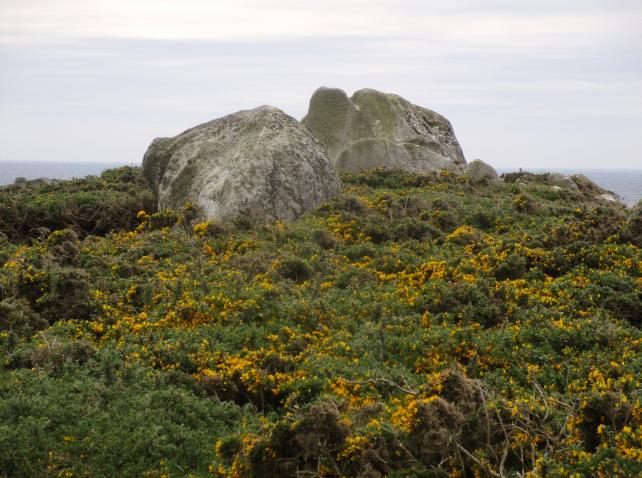
Wingletang Down is scattered with very fine granite outcrops. Boys Rock is not the biggest outcrop, but it earns a name on the Isles of Scilly 1:15,000 map published by Friendly Guides (the best walking map of Scilly). I looked for the bolt on a day trip to St Agnes, but I too couldnt find any sign of it, so Ive no reason to doubt the OS record that it was destroyed. There are two adjacent boulders Im not sure which is Boys Rock, or whether both collectively make up Boys Rock.
![]() Boys Rock, approaching from Barnabys Lane ©JonT
Boys Rock, approaching from Barnabys Lane ©JonT![]() Boys Rock (northern boulder) ©JonT
Boys Rock (northern boulder) ©JonT![]() Boys Rock (southern boulder) ©JonT
Boys Rock (southern boulder) ©JonT
![]() 13th Sep 2014 11:38 by jonglew
13th Sep 2014 11:38 by jonglew
FB Number: Not logged Condition: Destroyed Score: 5/10
OS records this bolt destroyed July 1960. There are some interesting weather shaped granite blocks at this location; searched most if not all of them but no sign of a bolt.
![]() 23rd May 2013 15:37 by dal
23rd May 2013 15:37 by dal
FB Number: Not logged Condition: Destroyed Score: 5/10
I could find no sign of the Bolt - therefore I will go with the OS Destroyed
![]() 1st Sep 2008 16:42 by Ant1974
1st Sep 2008 16:42 by Ant1974
FB Number: Not logged Condition: Destroyed Score: 5/10
![[map]](/img/trig-map.png.php?t=21616&b=2&l=0&)