![[UK map]](/img/locationmap.png)
| OSGB36 trig archive spreadsheet - IW | |||||||||||||
|---|---|---|---|---|---|---|---|---|---|---|---|---|---|
| Trig Name | Original Name | New Name | EASTING | NORTHING | HEIGHT | ORDER | TYPE OF MARK | Computing Date | CLASS OF LEVELLING | Date of Levelling | LEVELLING DATUM | DESTROYED MARK INDICATOR | COMMENTS |
| Cement Mixer | SU31/T438 | SU31T438 | 443830.19 | 104331.38 | 0.000 | 4 | SPIDER | 01/06/1954 | 0 | 1 | Dest 03/63 |
Nearby trigpoints, placenames
There are 4 photos for this trigpoint (view album).
This trigpoint:
Is ranked joint 21749th with 122 other trigs (more).
Has a mean score of 3.17/10 (from 6 logged visits)
Was First logged: 14th Feb 2012
Has never been found intact
Was Last logged: 10th Apr 2022
Of the 6 logged visits,
0 recorded a location
You are not logged in. You must login if you wish to log a visit.
![]() 10th Apr 2022 15:40 by mattandsophie
10th Apr 2022 15:40 by mattandsophie
FB Number: Not logged Condition: Destroyed Score: 5/10
Viewed from the road to the southeast but apparently destroyed
![]() 21st Jan 2017 09:51 by jonglew
21st Jan 2017 09:51 by jonglew
FB Number: Not logged Condition: Destroyed Score: 3/10
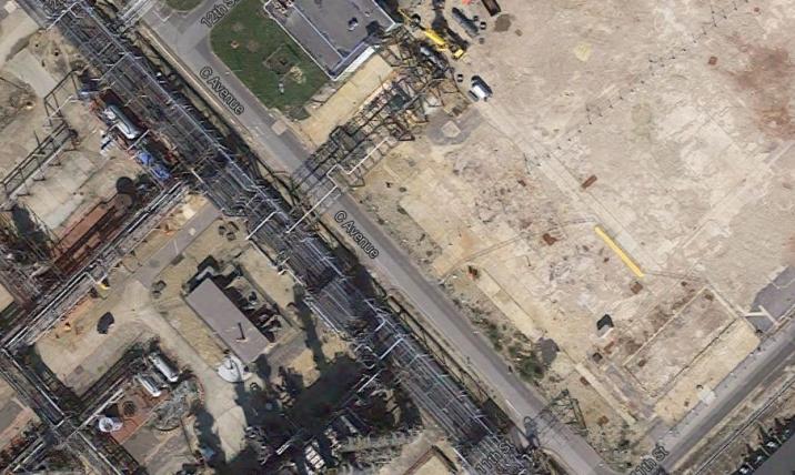
Destroyed March 1963. Closest it's possible to get to the location is Refinery Gate No 1, off Cadland Road. Comparing the 1962 1:10k map (which indicates the trig) with current Google Earth view, there's been a lot of changes in this area of the refinery over the past 50 years. Trig location in centre of both shots.
![]() 1962 1:10k map TP7947©jonglew
1962 1:10k map TP7947©jonglew![]() Google Earth view TP7947©jonglew
Google Earth view TP7947©jonglew
![]() 3rd Jul 2013 11:40 by CJO
3rd Jul 2013 11:40 by CJO
FB Number: Not logged Condition: Destroyed Score: 5/10
Reported destroyed 03/63. No access or clear views to the site.
![]() Cement Mixer View through BOC compound entrance
Cement Mixer View through BOC compound entrance
![]() 20th Oct 2012 15:07 by hotbox16
20th Oct 2012 15:07 by hotbox16
FB Number: Not logged Condition: Possibly missing Score: 0/10
No idea how you would get to this one
![]() 5th Apr 2012 14:21 by Griefmiester
5th Apr 2012 14:21 by Griefmiester
FB Number: Not logged Condition: Possibly missing Score: 1/10
No idea how you even get in here or what i was looking for! looks like a no go area unless you work there.
![]() 14th Feb 2012 12:49 by Trigger
14th Feb 2012 12:49 by Trigger
FB Number: Not logged Condition: Possibly missing Score: 5/10
See photo, this is about as far as I'm going to get!
![[map]](/img/trig-map.png.php?t=7947&b=2&l=0&)