![[UK map]](/img/locationmap.png)
| OSGB36 trig archive spreadsheet - IW | |||||||||||||
|---|---|---|---|---|---|---|---|---|---|---|---|---|---|
| Trig Name | Original Name | New Name | EASTING | NORTHING | HEIGHT | ORDER | TYPE OF MARK | Computing Date | CLASS OF LEVELLING | Date of Levelling | LEVELLING DATUM | DESTROYED MARK INDICATOR | COMMENTS |
| New Road | TQ13/T37 | TQ13T037 | 530722.02 | 114361.54 | 66.473 | 4 | BLOCK | 01/06/1952 | 1 | 01/06/1965 | N | 0 |
Nearby trigpoints, placenames
There are 5 photos for this trigpoint (view album).
This trigpoint:
Is ranked joint 22956th with 56 other trigs (more).
Has a mean score of 2.33/10 (from 3 logged visits)
Was First logged: 6th Jan 2013
Has never been found intact
Was Last logged: 29th Jun 2018
Of the 3 logged visits,
0 recorded a location
You are not logged in. You must login if you wish to log a visit.
Selection of photos for this Surface Block.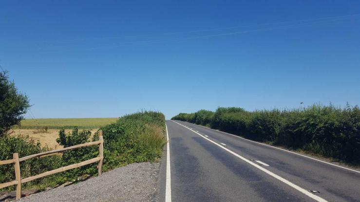 ©boblynoriho  ©JonT  ©JonT  ©JonT See 1 more in the album. |
![]() 29th Jun 2018 15:32 by boblynoriho
29th Jun 2018 15:32 by boblynoriho
FB Number: Not logged Condition: Couldn't find it Score: 1/10
A very busy road with little to no verge for protection. Didn't attempt to visit trig site but assume it will now be buried.
![]() New Road Trig meant to be alongside the blind summit in the road.©boblynoriho
New Road Trig meant to be alongside the blind summit in the road.©boblynoriho
![]() 4th Jun 2013 10:15 by JonT
4th Jun 2013 10:15 by JonT
FB Number: Not logged Condition: Couldn't find it Score: 1/10
Visited on a long, convoluted circular walk from Hassocks also visiting the Chattri (TP8993) and Wolstonbury Hill (TP7022) trig points. My GPS took me to the verge on the south side of the New Road (B 2112), at the top of a rise. I couldn't find any sign of the surface block - I suspect that its now buried, and you'd need a metal detector to find it. A particularly unpleasant location - fast traffic and narrow verges.
![]() New Road, looking south The surface block should be in the verge, below the hedge. ©JonT
New Road, looking south The surface block should be in the verge, below the hedge. ©JonT![]() New Road, looking west The surface block should be in the verge to the left, on the summit. Wolstonbury hill is on the horizon. ©JonT
New Road, looking west The surface block should be in the verge to the left, on the summit. Wolstonbury hill is on the horizon. ©JonT![]() Looking down on New Road from the Downs The trig point should be roughly where the white van is, in the middle of the picture.©JonT
Looking down on New Road from the Downs The trig point should be roughly where the white van is, in the middle of the picture.©JonT
![]() 6th Jan 2013 12:33 by Trigger
6th Jan 2013 12:33 by Trigger
FB Number: Not logged Condition: Couldn't find it Score: 5/10
![[map]](/img/trig-map.png.php?t=8221&b=2&l=0&)