![[UK map]](/img/locationmap.png)
| OSGB36 trig archive spreadsheet - IW | |||||||||||||
|---|---|---|---|---|---|---|---|---|---|---|---|---|---|
| Trig Name | Original Name | New Name | EASTING | NORTHING | HEIGHT | ORDER | TYPE OF MARK | Computing Date | CLASS OF LEVELLING | Date of Levelling | LEVELLING DATUM | DESTROYED MARK INDICATOR | COMMENTS |
| Cairn Hill | NT33/T20 | NT33T020 | 336506.01 | 638650.85 | 497.738 | 3 | BLOCK | 01/06/1959 | 2 | 01/06/1959 | N | 0 | HT TO BOLT IN BLOCK |
Nearby trigpoints, placenames
There are 7 photos for this trigpoint (view album).
This trigpoint:
Is ranked joint 4762nd with 64 other trigs (more).
Has a mean score of 5.75/10 (from 4 logged visits)
Was First logged: 29th Sep 2012
Was Last logged: 19th Nov 2022
Of the 4 logged visits,
2 recorded a location and of these....
All were within 4m
The average error was 3m
The closest was 2m
You are not logged in. You must login if you wish to log a visit.
Selection of photos for this Surface Block. By peregrinus  ©jonglew  By peregrinus  ©jonglew 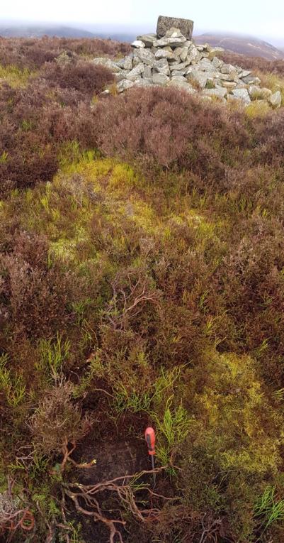 ©BigJ See 2 more in the album. |
![]() 19th Nov 2022 14:19 by peregrinus
19th Nov 2022 14:19 by peregrinus
FB Number: Not logged Condition: Good Score: 5/10
Metal rod in block 5.7m SSW of centre of main cairn, thanks BigJ. Uncovered, easy find. From SSE, track, rough grass, firebreak and open forest.
![]() Trig looking N Summit cairn and mountain bikers in background
Trig looking N Summit cairn and mountain bikers in background ![]() Trig looking W
Trig looking W
![]() 19th Nov 2022 13:31 by jonglew
19th Nov 2022 13:31 by jonglew
Gridref: NT 36508 38652 FB Number: Not logged Condition: Good Score: 6/10
Parked at Old Caberston, in a wide entrance at NT 3720 3769. Followed a new, unmapped, track partway, heading for a mapped break at NT 3681 3810, following it all the way up over steep rough ground. Block located quickly in heather due S of summit cairn, although over 2m less distance than the OS sketch, which stated 8m. With peregrinus, despite our apparent time difference.
![]() Surface Block - peregrinus points it out TP8349©jonglew
Surface Block - peregrinus points it out TP8349©jonglew![]() Surface Block - Detail, rod marker TP8349©jonglew
Surface Block - Detail, rod marker TP8349©jonglew
![]() 24th Dec 2018 12:01 by BigJ
24th Dec 2018 12:01 by BigJ
Gridref: NT 36506 38654 FB Number: Not logged Condition: Good Score: 7/10
Walked up from Old Caberston via the marked track which, in places, doesn't exist. Mast shown on map is absent as well. Bright frosty day encouraged me to spend a bit of time on this. Summit is very stoney but, after 45mins, stabbed what felt like a concrete slab. A bit of digging revealed a foot square slab with a 1/4" rod type bolt. Position is midway between the summit cairn and a low pile of stones situated due south of the cairn. (Ignore the small cairn to the SSE).
![]() ©BigJ
©BigJ![]() ©BigJ
©BigJ![]() ©BigJ
©BigJ
![]() 29th Sep 2012 13:55 by agentmancuso
29th Sep 2012 13:55 by agentmancuso
FB Number: Not logged Condition: Couldn't find it Score: 5/10
Had a good dig around, but lots of stones buried in the heather, so no luck. Suspect it mught be under the cairn.
![[map]](/img/trig-map.png.php?t=8349&b=2&l=0&)