Concrete Ring


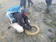
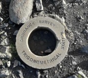
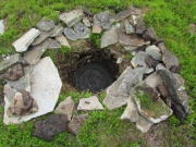
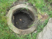
'Concrete Ring' is a trig bagger's term denoting a feature of some buried blocks seen in Lakes/Northern Pennines and elsewhere. Typically, the ring is approx 15" internal and 21" external diameter. It usually bears the inscription "Ordnance Survey Trigonometrical Station" although this may be eroded or absent. The ring is placed loosely above the block. The block itself typically has a central, slightly conical bolt of approx 3" diameter. Occasionally, a ring may be used to mark a buried bolt set into bedrock, for example, Brownsey Moor. Infrequently, the trig mark may be a rod instead of a bolt, for example, Stonesdale Moor.
Initially, when very few examples of concrete rings had been rediscovered, they
were considered by some baggers to be a decorative feature, lacking a functional use.
Subsequently, it was understood that they were identical to the OS term Emplacement Ring
(or Detector Ring) as described in
Section 7.032
and
Fig 7.7
of The History of the Retriangulation of Great Britain
[1] as follows:
When used as a secondary station a phosphor-bronze ring was buried with the block so as to
enable it to be detected by mine detectors if the locating description should prove insufficient.
With the lower order stations these rings were replaced by scrap iron incorporated in the block itself.
Some, but not all, concrete rings have an embedded metal ring (originally phosphor-bronze, subsequently iron). As with detector plates, the ring can assist in locating a trig when using a metal detector but is not in itself a mark.
It was discovered quite late on that the manufacturer decided to leave out the metal ring to save money. Hence many rings are just concrete [2].
The OS online records do not identify which blocks have emplacement rings, hence it is not known how many exist. The paper-based OS Office files (held at The National Archives) and Field files are understood to record this information although not systematically [3].
Until 2014, 10 Concrete Rings had been located, all in Northern England. However, they have subsequently been located more widely with 26 having been identified by late 2019, 51 by the end of 2022 and 55 by the end of 2023.
A photo album of concrete rings is available from T:UK, where a listing can also be accessed.
In 2018 the Concrete Ring on the buried block at Saddleback, located at the summit of Blencathra, was reported missing, presumed stolen. A replica was installed in early 2019 and has since suffered minor damage. The ring for Moss Farm was also lost, a few months after its rediscovery.
| T:UK | Station name | Order | Computed | Block | Rediscovered |
|---|---|---|---|---|---|
| TP19379 | Abercwmboi Auxiliary | 4 | 1953 | SO11 | 2 Jun 2019 |
| TP15266 | Ben Barvas | 2 | 1956 | NC20 | 17 May 2022 |
| TP16849 | Biggin Farm | 4 | 1957 | NZ42 | 28 Mar 2021 |
| TP17382 | Bleak Hill | 4 | 1954 | SE22 | 22 Nov 2021 |
| TP20335 | Brith-Weunydd | 4 | 1953 | ST07 | 26 May 2019 |
| TP8086 | Brownsey Moor | 3 | 1955 | SE38 | 8 Oct 2022 |
| TP19356 | Bryn Du | 4 | 1953 | SO11 | 20 Jul 2018 |
| TP23704 | Burchetts Green | 4 | 1952 | TQ08 | 24 May 2015 |
| TP17465 | Busk Moss | 3 | 1955 | SE38 | 16 Aug 2020 |
| TP19359 | Craig-Y-Gilfach | 4 | 1953 | SO11 | 3 Jun 2018 |
| TP19387 | Cwmaman | 4 | 1953 | SO11 | 23 May 2022 |
| TP25851 | Cwmaman Auxiliary | 4 | 1953 | SO11 | 23 May 2022 |
| TP17471 | Easterside Hill | 3 | 1955 | SE38 | 21 May 2022 |
| TP19360 | Ffos-Y-Fran Reservoir | 4 | 1953 | SO11 | 8 Jun 2019 |
| TP21679 | Four Burrows | 4 | 1955 | SX07 | 16 Apr 2022 |
| TP00057 | Gallow Hill | 3 | 1952 | NS29 | 23 Apr 2022 |
| TP20383 | Graig Fach | 4 | 1953 | ST07 | 6 Sep 2014 |
| TP19213 | Graig Fawr | 4 | 1953 | SO11 | 21 Jul 2019 |
| TP17473 | Great Haw | 3 | 1955 | SE38 | 24 Feb 2019 |
| TP7367 | Great Yarlside | 3 | 1961 | NY71 | 30 Jul 1988 |
| TP17474 | Greets Hill | 3 | 1955 | SE38 | 9 Jan 2022 |
| TP20397 | Gwaelod-Y-Garth | 4 | 1954 | ST07 | 28 Oct 2019 |
| TP17476 | Harland Hill | 3 | 1955 | SE38 | 9 Mar 2019 |
| TP16529 | High Banks | 2 | 1953 | NY45 | 29 Jan 2023 |
| TP7507 | High Seat | 3 | 1962 | NY71 | 30 Jul 1978 |
| TP17478 | Ivy Scar | 3 | 1955 | SE38 | 3 Oct 2022 |
| TP17479 | Jingle Pot | 3 | 1955 | SE38 | 21 Nov 2021 |
| TP17484 | Knavy Knot | 3 | 1955 | SE38 | 15 Jan 2023 |
| TP7379 | Knipe Moor | 3 | 1961 | NY71 | 4 Mar 1990 |
| TP17274 | Ladysmith Camp | 4 | 1952 | SD80 | 25 Oct 2022 |
| TP17480 | Lodge Pasture | 3 | 1955 | SE38 | 21 Apr 2019 |
| TP23701 | Maidenhead Thicket | 4 | 1952 | TQ08 | 12 Apr 2015 |
| TP17273 | May Hill | 4 | 1952 | SD80 | 5 Nov 2022 |
| TP17123 | Middle Dale | 3 | 1950 | SD47 | 6 Feb 2020 |
| TP17342 | Middle Healey | 4 | 1949 | SE02 | 3 Aug 2020 |
| TP16545 | Millstone Rigg | 4 | 1962 | NY71 | 5 Sep 2017 |
| TP17336 | Moss Farm | 4 | 1949 | SE02 | 3 Mar 2021 |
| TP25794 | Mynydd Aberdar Auxiliary | 4 | 1953 | SO11 | 5 Jun 2019 |
| TP19345 | North Merthyr Quarry | 4 | 1953 | SO11 | 7 Jul 2018 |
| TP20230 | Polmenna | 3 | 1949 | SS30 | 17 Apr 2022 |
| TP7306 | Saddleback | 3 | 1953 | NY45 | 8 Apr 1977 |
| TP7493 | Sails | 3 | 1962 | NY71 | 30 Jul 1978 |
| TP7368 | Seat Robert | 3 | 1961 | NY71 | 4 Mar 1990 |
| TP7307 | Selside Brow | 3 | 1961 | NY71 | 5 Jun 1991 |
| TP8083 | Shaw | 3 | 1955 | SE38 | 17 Sep 2022 |
| TP17275 | Slatepit Moor | 4 | 1952 | SD80 | 25 Oct 2022 |
| TP7380 | Stonesdale Moor | 3 | 1962 | NY71 | 9 Aug 2005 |
| TP17343 | Stormer Hill | 4 | 1949 | SE02 | 15 May 2019 |
| TP7506 | Swarth Fell Pike | 3 | 1962 | NY71 | 19 Dec 1998 |
| TP7818 | Tees Head | 3 | 1962 | NY71 | 20 Aug 2011 |
| TP19362 | Twyn Croes | 4 | 1953 | SO11 | 3 Aug 2018 |
| TP17453 | Virgin Moss | 3 | 1955 | SE38 | 23 Feb 2019 |
| TP17454 | Wasset Fell | 4 | 1955 | SE38 | 22 Aug 2020 |
| TP8362 | Heughscar Hill | 3 | 1961 | NY11 | 28 Aug 2023 |
| TP20307 | Hillsborough | 3 | 1949 | SS72 | 20 Dec 2023 |
| TP16817 | Danesly Hill | 3 | 1954 | NZ42 | 3 Feb 2024 |
| TP17475 | Grimbald Crag | 3 | 1955 | SE38 | 11 Feb 2024 |
| TP21394 | Pyle Hill | 3 | 1954 | SU77 | 11 Feb 2024 |
Since the number of rings emplaced is not known these stats may be not be based on a representative sample.
| T:UK | Station name | Order | Computed | Block | Notes |
|---|---|---|---|---|---|
| TP755 | Bolnhurst | 2 | 1938 | TL36 | Passive station sketch T1TL0559 refers to "B/B with Detector R" |
| TP17351 | Denehurst Farm | 4 | 1953 | SE02 | Sketch.
Document in Office file states "Detector Ring inserted". Station thought to be destroyed (land slip). |
| TP18663 | Linthwaite | 4 | 1954 | SK39 | Sketch 1 and 2.
The Reconnaissance Report mentions Detector Ring |
| TP17488 | Snilesworth Moor | 3 | 1955 | SE38 | Sketch.
The Reconnaissance report mentions 'Det Ring' and the Maintenance report states "Detector Material Situate: Yes Detector Ring" |
| TP16497 | Watch Hill | 3 | 1952 | NY11 | The Office File states "Detector Ring in place" but when found in Aug 2023 a Detector Plate was identified. |
| TP16498 | Aikbank | 3 | 1952 | NY11 | Station Inspectors Report "Buried Block Detector Ring" |
| TP16502 | Monkwray Brow | 3 | 1952 | NY11 | "Detector Ring in situ" |
| TP16504 | Redness | 3 | 1952 | NY11 | "Detector Ring" |
| TP23536 | Church Hill | 4 | 1951 | TQ00 | Pillar Constructors Report "Detector Ring was placed", "Depth of top of block 24 inches" |
| TP18950 | The Nurseries | 4 | 1950 | SK73 | Sketch.
Document in Office file states "Detector Ring". Housing on site; station probably destroyed. |
| TP16505 | Bankend | 3 | 1952 | NY11 | "B/Block 1'6" Below G.L with Detector Ring" |
| TP16539 | St Anns Hill | 3 | 1953 | NY45 | "Detector material situate Yes" (nature of material not specified) |
| TP21316 | Windmill Hill | 3 | 1951 | SU59 | "Detector Ring" |