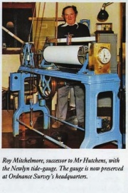
Tide gauge
Heights on maps are related to a determination of sea level around GB – this is defined by OS as Newlyn Datum. Heights are measured relative to a surface called the Geoid, the size and shape of which is determined by Gravity. The particular Geoid used in any region is that one that most nearly approximates to Mean Sea level in that Region. However tides are constantly disturbing the sea level shape away from the true Geoid shape. Hence tide gauges are needed to help determine sea level height. In the case of Newlyn Datum the geoid is defined by the tide gauge bolt at Newlyn. [1]
The tide gauge is described in [2] as follows: "General dissatisfaction with Liverpool as the national bench-mark datum led to the construction of three new tide gauges at Felixstowe, Newlyn and Dunbar, which began recording in 1913, 1915 and 1917 respectively. It had been intended to calculate the mean sea-level from the results obtained from all three, but it was found that although there was only 1/2 inch difference between Newlyn and Felixstowe mean sea levels, there was nearly 10 inches between Newlyn and Dunbar.
As a result Ordnance Survey decided to continue using a single reference datum. Newlyn was preferred as it was situated in an area of stable granite rock and because the gauge, perched on the end of a stone pier at the harbour entrance, was exposed to the open Atlantic. It was not therefore liable to be influenced by silting-up or the undue effects of estuary or river tide delays, as had been the case at Liverpool.
During six years of continuous recording, abstracts were made of the hourly records, from which mean sea-level was deduced. The gauge was checked twice daily, by manually measuring the drop to the surface of the water and comparing this with the recording on the tide-gauge. Barometric readings were taken, and the temperature and density of the sea water were also recorded.
Responsibility for the Newlyn tide gauge continued to rest with Ordnance Survey, who provided a full-time observer at the station until 1983 when the station was handed over to the Institute of Oceanographic Sciences."
References
- ↑ Emails from Ian Wilson to the Trigonomy mailing list, 27/08/2009 and 24 February 2012
- ↑ Ordnance Survey- Map Makers to Britain since 1791', Tim Owen and Elaine Pilbeam, p.85
