![[UK map]](/img/locationmap.png)
| OSGB36 trig archive spreadsheet - IW | |||||||||||||
|---|---|---|---|---|---|---|---|---|---|---|---|---|---|
| Trig Name | Original Name | New Name | EASTING | NORTHING | HEIGHT | ORDER | TYPE OF MARK | Computing Date | CLASS OF LEVELLING | Date of Levelling | LEVELLING DATUM | DESTROYED MARK INDICATOR | COMMENTS |
| Norwood Twr | TL05/T182 | TL05T182 | 509999.29 | 221321.74 | 0.000 | 4 | RIVET | 01/06/1970 | 0 | 0 |
Nearby trigpoints, placenames
There are 5 photos for this trigpoint (view album).
This trigpoint:
Is ranked joint 20144th with 59 other trigs (more).
Has a mean score of 3.71/10 (from 7 logged visits)
Was First logged: 6th Jul 2013
Has never been found intact
Was Last logged: 24th Apr 2024
Of the 7 logged visits,
1 recorded a location
The error was 0m
You are not logged in. You must login if you wish to log a visit.
Selection of photos for this Rivet. By Trigger  By peregrinus 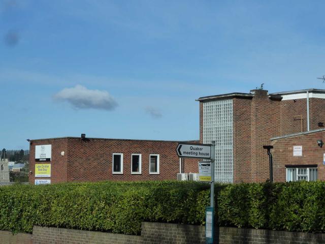 By CJO  By Father Ted  ©Arnand |
![]() 24th Apr 2024 06:42 by Trigger
24th Apr 2024 06:42 by Trigger
FB Number: Not logged Condition: Inaccessible Score: 5/10
![]() 19th Mar 2023 08:30 by peregrinus
19th Mar 2023 08:30 by peregrinus
FB Number: Not logged Condition: Inaccessible Score: 5/10
Yes appears to be stairwell tower at SE corner of building above Reception
![]() GMaps aerial view showing ex trig location
GMaps aerial view showing ex trig location
![]() 16th Apr 2017 09:03 by CJO
16th Apr 2017 09:03 by CJO
FB Number: Not logged Condition: Inaccessible Score: 5/10
Kestin House, Urban Saints Support centre - looks like a glazed stairwell tower.
![]() 10th Jul 2014 14:34 by Ant1974
10th Jul 2014 14:34 by Ant1974
FB Number: Not logged Condition: Inaccessible Score: 5/10
![]() 27th Jun 2014 19:16 by Father Ted
27th Jun 2014 19:16 by Father Ted
FB Number: Not logged Condition: Inaccessible Score: 2/10
Now seems to be a Christian Book Store. There looks to be quite a bit of works going on here including roadworks and demolition.
![]() 20th Sep 2013 17:05 by bluebeard
20th Sep 2013 17:05 by bluebeard
FB Number: Not logged Condition: Inaccessible Score: 1/10
presumed the rivet location was on the roof
![]() 6th Jul 2013 12:24 by Arnand
6th Jul 2013 12:24 by Arnand
Gridref: TL 09999 21321 FB Number: Not logged Condition: Couldn't find it Score: 3/10
4th order Rivet station number TL05/T182. Again without a map couldn't find this rivet
![]() Rivets reported location ©Arnand
Rivets reported location ©Arnand
![[map]](/img/trig-map.png.php?t=12582&b=2&l=0&)