![[UK map]](/img/locationmap.png)
| OSGB36 trig archive spreadsheet - IW | |||||||||||||
|---|---|---|---|---|---|---|---|---|---|---|---|---|---|
| Trig Name | Original Name | New Name | EASTING | NORTHING | HEIGHT | ORDER | TYPE OF MARK | Computing Date | CLASS OF LEVELLING | Date of Levelling | LEVELLING DATUM | DESTROYED MARK INDICATOR | COMMENTS |
| Lower Simli Field | HU46/T28 | HU46T028 | 418469.40 | 1150885.06 | 105.649 | 3 | RIVET | 01/06/1961 | 1 | 01/06/1961 | L | 0 | ROOF STATION APPROX 3M ABOVE GL |
Nearby trigpoints, placenames
There are 12 photos for this trigpoint (view album).
This trigpoint:
Is ranked joint 4888th with 87 other trigs (more).
Has a mean score of 5.71/10 (from 7 logged visits)
Was First logged: 16th Apr 2012
Has never been found intact
Was Last logged: 5th Sep 2020
Of the 7 logged visits,
5 recorded a location and of these....
All were within 6m
The average error was 3m
1 was exact
You are not logged in. You must login if you wish to log a visit.
Selection of photos for this Rivet. ©jonglew  ©jonglew  ©jonglew 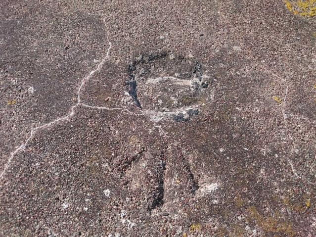 ©Da Lipper 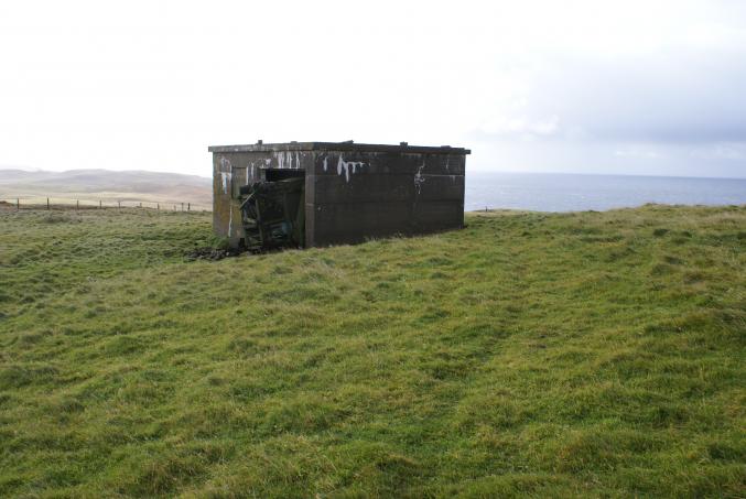 ©edfielden  ©edfielden See 6 more in the album. |
![]() 5th Sep 2020 16:22 by GAnder88
5th Sep 2020 16:22 by GAnder88
FB Number: Not logged Condition: Remains Score: 8/10
![]() 26th Jun 2019 20:10 by jonglew
26th Jun 2019 20:10 by jonglew
Gridref: HU 18469 50891 FB Number: Not logged Condition: Remains Score: 5/10
Roadside parking to NE, track leads to a square format WWII bldg, block structure with concrete slab for roof with rivet at centre. Access a little tricky, made use of old farm machinery to scramble up. The trig is also a Benchmark and therefore has the cut arrow, just as well as the rivet has gone, just leaving the arrow as evidence. Descending proved awkward, mainly as concrete at edge of the roof is rotting and no longer stable.
![]() The Bldg TP8199©jonglew
The Bldg TP8199©jonglew![]() Up on the roof TP8199©jonglew
Up on the roof TP8199©jonglew![]() Light not brilliant but arrow visible TP8199©jonglew
Light not brilliant but arrow visible TP8199©jonglew
![]() 10th Jun 2019 20:49 by peregrinus
10th Jun 2019 20:49 by peregrinus
FB Number: Not logged Condition: Remains Score: 5/10
Managed a view of it from windowsill
![]() 13th May 2018 10:45 by dmwhite
13th May 2018 10:45 by dmwhite
Gridref: HU 18474 50884 FB Number: Not logged Condition: Remains Score: 6/10
Managed to haul myself up onto roof to view carved markings. Foula visible above slight sea mist. Breezy day so didn't stay around long.
![]() 17th Aug 2017 11:51 by Da Lipper
17th Aug 2017 11:51 by Da Lipper
Gridref: HU 18471 50879 FB Number: Not logged Condition: Remains Score: 6/10
![]() ©Da Lipper
©Da Lipper![]() ©Da Lipper
©Da Lipper
![]() 19th Sep 2012 09:57 by edfielden
19th Sep 2012 09:57 by edfielden
Gridref: HU 18467 50886 FB Number: Not logged Condition: Remains Score: 5/10
OS trig database states "ROOF STATION APPROX 3M ABOVE GL". So, taking my trusty telescopic ladder along I walked the 300m from the road to the WWII concrete building that martine41 had been next to. I climbed gingerly onto the roof to see what I could find. Apart from several incongruous stones scattered on the top, lo and behold, in the centre of the roof there is a depression in the surface next to an embossed benchmark symbol. No sign of a rivet but it must have been here. Follow in my steps at your own risk etc. Nice outlook from the rooftop - Foula visible once again shrouded in cloud!
![]() Lower Simli Field - Approach view Looking S ©edfielden
Lower Simli Field - Approach view Looking S ©edfielden![]() Lower Simli Field - Ladder access! Looking E ©edfielden
Lower Simli Field - Ladder access! Looking E ©edfielden![]() Lower Simli Field - The rooftop Looking SE; the rivet position is hiding behind the large rock in the middle ©edfielden
Lower Simli Field - The rooftop Looking SE; the rivet position is hiding behind the large rock in the middle ©edfielden![]() Lower Simli Field - Rivet position Embossed benchmark symbol next to surface depression ©edfielden
Lower Simli Field - Rivet position Embossed benchmark symbol next to surface depression ©edfielden![]() View WSW Dogs Head in foreground, Foula in distance ©edfielden
View WSW Dogs Head in foreground, Foula in distance ©edfielden
![]() 16th Apr 2012 11:36 by martine41
16th Apr 2012 11:36 by martine41
Gridref: HU 18469 50885 FB Number: Not logged Condition: Not Logged Score: 5/10
The location has a number of WW2 buildings. Despite my Satmap GPS logging grid reference accuracies of between 6' and 13', no evidence of a rivet was found. The area is on high ground and gives good views in most relevant directions except where blocked by adjacent WW2 building.
![]() Location of logged grid reference According to my GPS the grid ref is by the near left hand corner of the building
Location of logged grid reference According to my GPS the grid ref is by the near left hand corner of the building![]() Location of logged grid reference. Logged grid ref according to my GPS is just to the right of the far corner of the building.
Location of logged grid reference. Logged grid ref according to my GPS is just to the right of the far corner of the building.
![[map]](/img/trig-map.png.php?t=8199&b=2&l=0&)