![[UK map]](/img/locationmap.png)
| OSGB36 trig archive spreadsheet - IW | |||||||||||||
|---|---|---|---|---|---|---|---|---|---|---|---|---|---|
| Trig Name | Original Name | New Name | EASTING | NORTHING | HEIGHT | ORDER | TYPE OF MARK | Computing Date | CLASS OF LEVELLING | Date of Levelling | LEVELLING DATUM | DESTROYED MARK INDICATOR | COMMENTS |
| Arnish | NC20/H126 | NC20H126 | 142115.58 | 931024.29 | 57.912 | 4 | BLOCK | 01/06/1961 | 2 | 01/06/1961 | S | 0 | HT TO BOLT IN BLOCK |
Nearby trigpoints, placenames
There are 10 photos for this trigpoint (view album).
This trigpoint:
Is ranked joint 6564th with 87 other trigs (more).
Has a mean score of 5.40/10 (from 5 logged visits)
Was First logged: 16th Oct 2013
Was Last logged: 19th Sep 2019
Of the 5 logged visits,
2 recorded a location and of these....
All were within 2m
The average error was 1m
1 was exact
You are not logged in. You must login if you wish to log a visit.
Selection of photos for this Surface Block.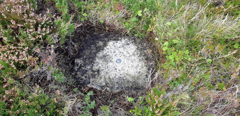 ©jonglew 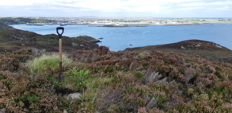 ©jonglew  ©jonglew  By peregrinus  ©mrs moo cow See 5 more in the album. |
![]() 19th Sep 2019 14:27 by jonglew
19th Sep 2019 14:27 by jonglew
Gridref: NB 42115 31024 FB Number: Not logged Condition: Good Score: 6/10
Roadside parking on good tarmac'd road leading to business park / industrial area (NB 4199 3099). About 150m of awkward deep heather to small hill giving extensive views to Stornoway etc. 1" Bolt in concrete block few metres off the hill top, exposed in the heather, rendering my spade redundant on this occasion. Block is loose in the ground, tilts back and forth when standing on it.
![]() Surface Block - Location TP8256©jonglew
Surface Block - Location TP8256©jonglew![]() Surface Block TP8256©jonglew
Surface Block TP8256©jonglew![]() Surface Block - Detail TP8256©jonglew
Surface Block - Detail TP8256©jonglew
![]() 26th May 2019 15:09 by joeythecat
26th May 2019 15:09 by joeythecat
Gridref: NB 42113 31024 FB Number: Not logged Condition: Good Score: 5/10
Luckily had a chance for a revisit a few days after peregrinus had uncovered it.
![]() 18th May 2019 19:57 by peregrinus
18th May 2019 19:57 by peregrinus
FB Number: Not logged Condition: Slightly damaged Score: 5/10
1" bolt in concrete block, 1.5m S of grassy knoll. Was under heather, left open to view.
![]() bolt
bolt ![]() block looking SE
block looking SE ![]() block looking N
block looking N ![]() block looking S
block looking S
![]() 3rd Jun 2018 11:15 by joeythecat
3rd Jun 2018 11:15 by joeythecat
FB Number: Not logged Condition: Couldn't find it Score: 5/10
Even with the help of Mrs Moo Cow's photos, I couldn't find it under the deep heather.
![]() 16th Oct 2013 14:14 by mrs moo cow
16th Oct 2013 14:14 by mrs moo cow
FB Number: Not logged Condition: Good Score: 6/10
Found on a run from Lewis Castle. The easiest aproach would be to follow the road signed Arnish Industrial Estate until you reach the highest point on the seaward side (plenty of parking potential along the road). Climb across the ditch and dodge various boggy bits to reach the top, Had to clear the heather off to find the block which is actually quite loose but has a nice stud in it. Good views across the Stornoway harbour & beyond the nearby lighthouse.
![]() Arnish Hydrographic Survey Station Arnish Hydrographic Survey Station©mrs moo cow
Arnish Hydrographic Survey Station Arnish Hydrographic Survey Station©mrs moo cow![]() Arnish Hydrographic Survey Station Arnish Hydrographic Survey Station©mrs moo cow
Arnish Hydrographic Survey Station Arnish Hydrographic Survey Station©mrs moo cow![]() Arnish Hydrographic Survey Station Arnish Hydrographic Survey Station©mrs moo cow
Arnish Hydrographic Survey Station Arnish Hydrographic Survey Station©mrs moo cow
![[map]](/img/trig-map.png.php?t=8256&b=2&l=0&)