![[UK map]](/img/locationmap.png)
| OSGB36 trig archive spreadsheet - IW | |||||||||||||
|---|---|---|---|---|---|---|---|---|---|---|---|---|---|
| Trig Name | Original Name | New Name | EASTING | NORTHING | HEIGHT | ORDER | TYPE OF MARK | Computing Date | CLASS OF LEVELLING | Date of Levelling | LEVELLING DATUM | DESTROYED MARK INDICATOR | COMMENTS |
| Plantation | SE73/T76 | SE73T076 | 454788.09 | 402526.17 | 33.299 | 13 | BLOCK | 01/06/1988 | 3 | 01/06/1988 | N | 0 | GPS HEIGHT NCE 88 |
Nearby trigpoints, placenames
There are 4 photos for this trigpoint (view album).
This trigpoint:
Is ranked joint 23079th with 45 other trigs (more).
Has a mean score of 2.60/10 (from 5 logged visits)
Was First logged: 21st Sep 2013
Has never been found intact
Was Last logged: 10th Jun 2023
Of the 5 logged visits,
0 recorded a location
You are not logged in. You must login if you wish to log a visit.
![]() 10th Jun 2023 13:00 by ted
10th Jun 2023 13:00 by ted
FB Number: Not logged Condition: Possibly missing Score: 0/10
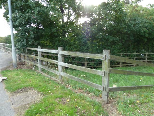
The OS sketch at https://trigpointing.uk/wiki/File:TP8501_Plantation_Sketch.jpg shows various short measures from the trig, including a lamppost, roadside drain and to the start of the pavement across the motorway bridge. The latter was indeterminate but the end of the concrete parapet gave a close approximation. The search was therefore confined to a small area. The distance from lamppost to wooden fence was measured as 0.75m, matching the sketch distance 'a'. This implied that the trig was below the fence whereas the sketch showed a gap, suggesting that the fence may have been reconstructed nearer the road. Measured sketch distance 'b' parallel to the fence, to a position slightly W of the lamppost. Vegetation cleared and verge probed. Ground fairly soft but numerous small stones hindered progress. Nothing of interest found. Gave up after about 20 mins - too warm for digging today. The sketch doesn't show the driveway and gate. It seems possible that the present fence was installed at the same time and the change to the boundary line resulted in the trig's demise. But the next visitor might wish to take a spade and excavate a little deeper to confirm.
![]() Plantation site
Plantation site![]() Plantation site
Plantation site
![]() 23rd Mar 2023 10:46 by FrankR
23rd Mar 2023 10:46 by FrankR
FB Number: Not logged Condition: Possibly missing Score: 5/10
![]() 23rd Mar 2019 10:18 by eon
23rd Mar 2019 10:18 by eon
FB Number: Not logged Condition: Possibly missing Score: 1/10
(1277) Parked in entrance way across the road. Rough track at location. Suspect this one is gone as well.
![]() Plantation. ©eon
Plantation. ©eon
![]() 19th Jul 2018 23:11 by Ant1974
19th Jul 2018 23:11 by Ant1974
FB Number: Not logged Condition: Possibly missing Score: 5/10
![]() 21st Sep 2013 08:53 by CJO
21st Sep 2013 08:53 by CJO
FB Number: Not logged Condition: Possibly missing Score: 2/10
GPS points to ground on rough entrance track covered in grass and gravel. quick prod showed futility in continuing together with the rather blunt GOML notice.
![[map]](/img/trig-map.png.php?t=8501&b=2&l=0&)