![[UK map]](/img/locationmap.png)
| OSGB36 trig archive spreadsheet - IW | |||||||||||||
|---|---|---|---|---|---|---|---|---|---|---|---|---|---|
| Trig Name | Original Name | New Name | EASTING | NORTHING | HEIGHT | ORDER | TYPE OF MARK | Computing Date | CLASS OF LEVELLING | Date of Levelling | LEVELLING DATUM | DESTROYED MARK INDICATOR | COMMENTS |
| An Cabar | NH16/T17 | NH16T017 | 225735.00 | 864110.12 | 558.192 | 3 | PILLAR | 01/06/1958 | 1 | 01/07/1958 | N | 0 |
Nearby trigpoints, placenames
There are 9 photos for this trigpoint (view album).
This trigpoint:
Is ranked joint 1363rd with 29 other trigs (more).
Has a mean score of 6.71/10 (from 14 logged visits)
Was First logged: 6th Jun 2007
Was Last logged: 3rd Sep 2023
Of the 14 logged visits,
4 recorded a location and of these....
All were within 36m
The average error was 16m
The closest was 4m
You are not logged in. You must login if you wish to log a visit.
Selection of photos for this Pillar. By trigging on an island  By clochandighter 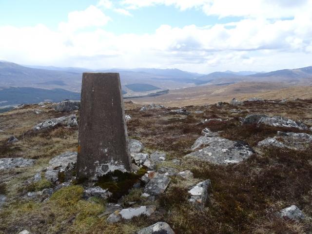 ©fasgadh  ©fasgadh  ©fasgadh See 4 more in the album. |
![]() 3rd Sep 2023 13:30 by trigging on an island
3rd Sep 2023 13:30 by trigging on an island
FB Number: S9494 Condition: Slightly damaged Score: 8/10
With Tony J whilst travelling across to the RHSoc gathering over in Aultbea. Decent walk up a very fine hill even if the prevailing winds were unabating and fierce for the whole duration.
![]() 18th Aug 2022 12:00 by Fraserbean
18th Aug 2022 12:00 by Fraserbean
FB Number: Not logged Condition: Not Logged Score: 5/10
![]() 11th Jul 2022 13:31 by clochandighter
11th Jul 2022 13:31 by clochandighter
Gridref: NH 25738 64098 FB Number: S9494 Condition: Slightly damaged Score: 9/10
Overall approach from southwest. Parked in large layby on south side of A832 at NH 23906 61288. A good track leaves the north side of the A832 at NH 24219 61393. This track only appears on some maps. Once over the locked deer gate this track leads up through the woods joining what was a mapped path and continues onto the open deer moor until NH 24196 62510 (~312m height). After the track ends, it is a straight-forward route upwards of around 2km northeast across heather and occasional bogs until the summit is reached. Standard Hotine triangulation pillar. The column trunk has sustained damage below the flush bracket, otherwise is still in reasonable condition. Spider retains original OS centre cap with deep indented letters. Flush bracket faces northwest, compass measurement 300°. Vented through front and right sight holes. Full 360° panoramic view from top.
![]() S9494 - An Cabar route map.
S9494 - An Cabar route map.
![]() 23rd Jan 2020 11:44 by BigJ
23rd Jan 2020 11:44 by BigJ
Gridref: NH 25737 64114 FB Number: S9494 Condition: Slightly damaged Score: 6/10
Up from near Strathbran Lodge. Driving rain and mist made for a drookit ascent. No view unfortunately.
![]() 6th May 2019 13:26 by fasgadh
6th May 2019 13:26 by fasgadh
FB Number: S9494 Condition: Slightly damaged Score: 9/10
Up from Loch Fannich in cold weather with snow showers. Very good views, especially of the big Fannich hills and the loch. There is a hole in the concrete below the fb.
![]() An Cabar Summit area from the north©fasgadh
An Cabar Summit area from the north©fasgadh![]() An Cabar ©fasgadh
An Cabar ©fasgadh![]() An Cabar Slight damage below the flush bracket©fasgadh
An Cabar Slight damage below the flush bracket©fasgadh![]() An Cabar ©fasgadh
An Cabar ©fasgadh
![]() 26th Sep 2018 00:00 by caroleengel
26th Sep 2018 00:00 by caroleengel
Gridref: NH 25739 64099 FB Number: Not logged Condition: Slightly damaged Score: 5/10
From Strathbran Lodge to SW - mapped path/track indistinct from road but soon meets vehicle track which continues thru' forest to ATV to Loch na Curra. With TuMP Carn Daraich to WSW and An Cabar W top (to west!) - a 5H
![]() 8th May 2018 10:17 by NormanW
8th May 2018 10:17 by NormanW
FB Number: Not logged Condition: Slightly damaged Score: 5/10
![]() 9th Oct 2017 17:12 by Robert Phillips
9th Oct 2017 17:12 by Robert Phillips
FB Number: Not logged Condition: Slightly damaged Score: 5/10
![]() 27th Oct 2013 11:32 by nozzer
27th Oct 2013 11:32 by nozzer
FB Number: Not logged Condition: Slightly damaged Score: 5/10
solo up from the loch Fannich
![]() 6th Jun 2013 22:01 by DeniseMc
6th Jun 2013 22:01 by DeniseMc
FB Number: Not logged Condition: Not Logged Score: 5/10
![]() 11th May 2010 12:30 by Chalky
11th May 2010 12:30 by Chalky
FB Number: S9494 Condition: Good Score: 8/10
VGC with spider intact, the cap having indented lettering. Good views of Fannichs,Fisherfield , Torridons etc. Previously visited this Marilyn 22/11/00,no trig details noted.
![]() 12th Jun 2008 14:30 by spidym
12th Jun 2008 14:30 by spidym
FB Number: S9494 Condition: Slightly damaged Score: 8/10
Great walk up. Came with friend. Followed path from StrathBran Lodge, then cut across NE to Trig. Fantastic views over Loch Fannich (north). As mentioned before small damage below FB. Overall Good trek. Nearly lost car keys as well :p
![]() The trig itself
The trig itself ![]() looking North East
looking North East ![]() Looking North West over Loch Fannich
Looking North West over Loch Fannich
![]() 26th May 2008 09:30 by peregrinus
26th May 2008 09:30 by peregrinus
FB Number: S9494 Condition: Slightly damaged Score: 8/10
Slight damage below FB. Metal cap, deep letters. Nice rocky summit, fine view. S top of Carn na Beiste to the E, has an unmapped Hydro Board pillar (presumably for Fannich Dam and resr, which it has an excellent view of). 2nd visit: was here in 28/6/02 - was my 1500th Marilyn.
![]() 6th Jun 2007 15:05 by arranc
6th Jun 2007 15:05 by arranc
Gridref: NH 25700 64100 FB Number: S9494 Condition: Slightly damaged Score: 8/10
stalkers' path through forest, then a crossing of the moor on compass. no cairn. nearby rocks obviously higher than bench plate.
![[map]](/img/trig-map.png.php?t=834&b=2&l=0&)