Fundamental Benchmark
A Fundamental Bench Mark (FBM) consists of an underground chamber topped with a
short pillar (originally granite but subsequently concrete).
FBMs were constructed for the Second Geodetic Levelling (1912-1921).
They were used for height control only; historically they never had a precise plan position.
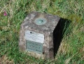
The pillar contains an easily accessible height reference point, marked with a tag. But the accurately measured level is underground where it is less likely to be disturbed. In addition, the FBM is sometimes protected by railings. There are usually two plaques on the FBM; the original 'Ordance Survey BM' (BM later changed to 'Benchmark') and a GPS plaque.
There are approximately 207 FBMs across the country and, whilst a few have fallen into disuse, most have been incorporated into the National GPS Network as Passive stations. A list is available on T:UK.
Work was carried out between 1998 and 2002 to occupy all FBMs and a large number of Trig Pillars with dual-frequency GPS in order to improve the 2D and height transformation models. This was the first time FBMs had a precise 3D position computed. This work resulted in OSTN02 and OSGM02. [1]
Many FBMs could not be occupied by GPS because of local obstructions (trees, etc). So Aux stations were installed near the FBMs and precise levelling carried out from the FBM to the Aux. This effectively moved the FBM to a position where GPS observations were possible. [2]
Although Gravity Stations have a similar appearance, they are not FBMs.

Broomhead Moor FBM - railings

Forcett FBM - plaques on a granite pillar
Kirkby Stephen FBM - concrete pillar
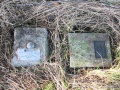
Northallerton FBM - in two parts
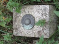
Skipton FBM - height tag

Waltham FBM - circular pillar

An FBM in use(location unknown)


